Rencana Detail
Tata Ruang (RDTR)
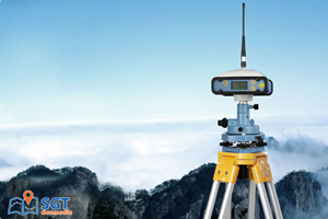
High-accuracy environmental and oceanographic data collection using integrated meteorological and oceanographic systems for offshore planning, marine operations, and coastal engineering.
99%
Data Reliability
3D
Continuous Observation
500+
Projects Completed
Advanced Drones
High-performance UAVs
Technology
Millimeter precision
What is RDTR?
Rencana Detail Tata Ruang (RDTR) Berbasis GIS adalah sistem perencanaan spasial yang memanfaatkan teknologi pemetaan digital untuk menyajikan informasi detail tentang pemanfaatan ruang di wilayah kabupaten/kota secara interaktif dan terintegrasi. RDTR GIS menyajikan data spasial dan non-spasial yang akurat, yang dapat digunakan sebagai dasar perizinan, perencanaan teknis sektoral, serta pengendalian pemanfaatan ruang. Dengan dukungan teknologi GIS, RDTR menjadi lebih dinamis, mudah diakses, dan mendukung proses analisis spasial secara cepat dan tepat. RDTR GIS meliputi:
Benefits of Rencana Detail Tata Ruang (RDTR) GIS
Our survey solutions offer key advantages for operational planning, offshore engineering, and environmental assessment.
Real-time Ocean Condition Monitoring
Menyediakan data waktu nyata tentang arus, gelombang, suhu laut, dan tekanan udara untuk mendukung keputusan operasional yang cepat dan tepat.
Operational Safety
Membantu menjamin keselamatan kegiatan operasional laut dan lepas pantai melalui prediksi kondisi cuaca ekstrem dan perubahan lingkungan laut.
Integrated Weather & Current Data
Menggabungkan data meteorologi dan oseanografi (metocean) secara sinkron untuk kebutuhan perencanaan dan analisis risiko.
Project Planning Efficiency
Mengurangi ketidakpastian dalam perencanaan proyek kelautan melalui data historis dan prediksi yang akurat.
Environmental Risk Assessment
Menunjang kajian dampak lingkungan dengan pemahaman yang lebih baik tentang dinamika laut dan cuaca jangka panjang.
Support for Offshore Development
Menyediakan informasi dasar untuk eksplorasi energi laut, pembangunan platform, serta kegiatan konstruksi di wilayah pesisir dan laut dalam.
Applications
Our drone technology serves multiple industries with tailored solutions

Urban Planning & Development
Our LIDAR drone technology revolutionizes urban planning by providing highly accurate 3D models of cities and built environments. This enables better decision-making for development projects.
- Create detailed 3D city models for visualization and planning
- Analyze building heights, densities, and urban patterns
- Plan infrastructure development with precise spatial data
- Assess flood risks and optimize drainage patterns

Construction & Engineering
LIDAR drone technology transforms construction projects by providing accurate measurements and monitoring capabilities throughout the project lifecycle.
- Generate accurate terrain models for site planning
- Calculate precise earthwork volumes for cost estimation
- Monitor construction progress with regular surveys
- Detect structural deformations and quality issues

Forestry & Environmental
Our LIDAR technology excels in forestry applications by penetrating canopy cover to provide detailed information about both vegetation and ground surfaces.
- Measure tree heights and canopy coverage accurately
- Assess biomass and carbon storage potential
- Monitor deforestation and forest regrowth patterns
- Map wildlife habitats and ecological corridors

Mining & Resource Management
LIDAR drone technology provides mining operations with accurate volumetric measurements and site monitoring capabilities for improved efficiency and safety.
- Calculate stockpile volumes with high precision
- Monitor pit wall stability and detect potential hazards
- Plan extraction sequences based on accurate terrain data
- Assess environmental impact and plan rehabilitation
Our Equipment
We use only the most advanced technology to ensure optimal results

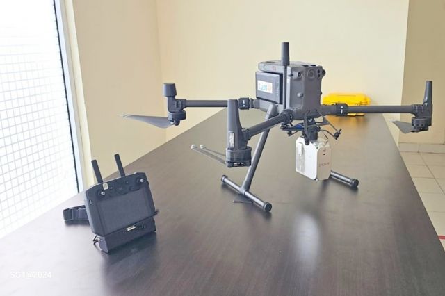
DJI Matrice 300 RTK
Industrial drone platform with extended flight time and advanced safety features
- 55-minute flight time
- 15km transmission range
- IP45 weather resistance

Livox Avia LIDAR
High-precision LIDAR sensor with 450m range and multi-return capability
- 240,000 points per second
- ±2cm accuracy
- Triple return capability

Advanced Processing Software
Industry-leading software for point cloud processing and 3D model generation
- Automated point cloud classification
- Mesh and surface modeling
- Multiple export formats